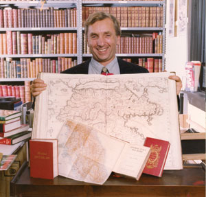
Kenneth Gloss, proprietor of Brattle Book Shop, proudly displays a few collectible maps.
By Kenneth Gloss
If you’re looking to start a collection that combines history and value, or just creates a great conversation piece, try maps. Not only do they look nice as prints in dens and offices, but they also provide a nice step back into time. You can see what your neighborhood looked like 100 years ago or provide a view of a city like New York back when horse and buggy was the primary mode of transportation.
A few years ago, one of the greatest collections of maps in the Boston area was donated to the Boston Public Library by Norman B. Leventhal. This collection, set up in 2004, is vast, containing 200,000 maps and 5,000 atlases. They included everything from Colonial Boston to maps of Boston during the 19th Century. Leventhal had done a lot of work in the area with his real estate business over the years and amassed one of the most impressive map collections around, dating all the way from the 1400s to the turn of the century. Seeing this collection takes you on a true visual historical tour of the area.
Leventhal is also a contributing author to the book Mapping Boston, which can give potential map collectors a nice look at what kinds of period maps are available and how looking at them can really put an area’s history into context. This is a fascinating book that really charts the history of the Boston area.
Maps are continuously going up in value, particularly as they become harder to find. However, for a collector, it’s the memory or the event itself, which often spurs the purchase of the piece, not necessarily the value. I have a map of Back Bay from the 1860s, where the values are penciled in for each of the properties. You can see that the buyers bought one piece of land for two dollars a square foot, another piece for three dollars a square and one can actually see the area getting laid out. It doesn’t, of course, look exactly that way anymore, but it’s an interesting snippet of history and actually makes that moment in time come alive.
Since map collecting is a rather broad area, try narrowing your collection to a specific region, town or time period. You could start with your hometown or city, for instance.
Sometimes, you’ll find a map in an unexpected place. I once came across a book by a man named Ledyard, who had served under Captain Cook. He had written an account of his high-seas adventures, which sells for $5000 to $6000 without the map inside it. In those days, readers had the option of buying the book with or without the map and most opted not to pay the extra money, so there are few copies that exist with that extra feature. This copy, however, did have its map, the first American map ever made of the Hawaiian Islands. Because of that, the book sold for $50,000.
The original map of Lewis and Clark’s expedition, detailing their route through the country and along the rivers, on their quest to reach the Pacific Ocean, sells for $50,000. To me, that map is interesting because when you see it; you realize how difficult their trip really was.
Another fun area of map collecting where the maps can range from a few dollars to a few hundred dollars is the category of old automobile maps, the kind that used to be given out at gas stations from the 1920s to the 1940s. These were really interesting, not just because of the nice graphics on their covers, but because of the differences they show in how the roads and highways have changed across the United States.
You don’t have to collect just maps. I know one collector who has augmented his collection of maps and atlases of central Europe with postcards from that area. He’s made it challenging for himself, too, by trying to find a postcard from every location on the maps. It’s not as easy as it sounds, particularly in Europe, because many of those locations no longer exist. The place names have changed a great deal since the turn of the 19th Century.
War and battlefield maps are another area of continual fascination for collectors; particularly the detailed ones that show day-to-day troop movement, whether it’s under Napoleon, or during the Civil War. Some of these maps appeared in newspapers of the day, providing updates for the people back home.
The maps in the National Geographic post-1920 are not so rare because the magazine was widely distributed (any from issues before that year are rarer). I sell a number of the post-1920 maps to college students who buy them for wrapping paper, looking for something a little cool and different.
Even as technology is changing, it’s creating new areas of collecting. I am sure that there will be collectors who will start collections of everything from GPS brochures or earlier GPS machine models and from map sites on the Internet such as those that show specific streets in various neighborhoods. For nearly everything, there is a collection, and with maps, those collections give you a visual peek at the history right under your feet.
Ken Gloss is the owner of the Brattle Book Shop in downtown Boston. It is the oldest continuously operated antiquarian bookstore in the United States. 2011 is the 63rd year of Gloss family ownership. Ken is a frequent guest on “Antiques Roadshow” on PBS. For further information and a schedule of Ken’s free and open talks, visit www.brattlebookshop.com or call 1-800-447-9595.





Reader Comments