Pages
Stay In Touch
More
© 2021 The Somerville Times. All rights reserved.

(The opinions and views expressed in the commentaries and letters to the Editor of The Somerville Times belong solely to the authors and do not reflect the views or opinions of The Somerville Times, its staff or publishers)
By Will Mbah
Candidate for Somerville City Councilor at Large
willmbah.com
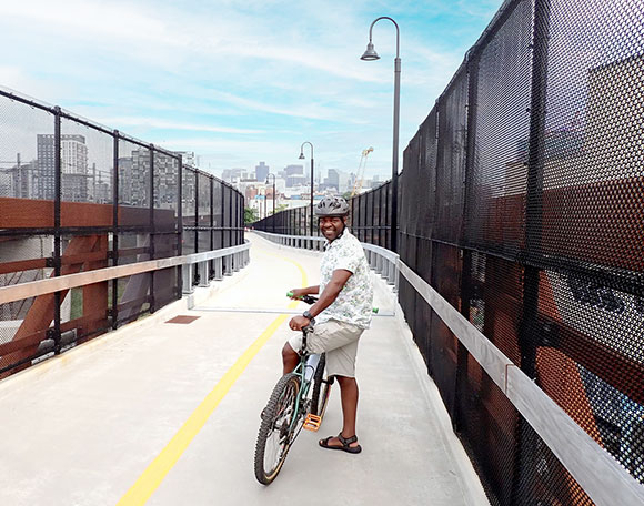
This week I took an hour to try out the new stretch of the Community PATH that heads through Gilman Square, East Somerville and Brickbottom to the final points at North Point Park. It was a smooth and enjoyable ride on a sunny late Friday afternoon. How satisfying to move quickly over the bridges and look down on the backed-up cars on McGrath and Washington Streets! What fun to pick up a bit of speed down the roller coaster ride from the highest point next to Brickbottom down to Lechmere!
This little fast joy ride was okay because there were not many folks out biking and walking last week. The city and MBTA wisely made the decision to open the PATH quietly, delaying the ceremonies and ribbon cutting for a couple of weeks. This has given them the ability to fix any final problems that may come to light as use gradually increases.
I can report one important problem – a lack of direction signs and crossing controls. This seems to be a particular problem at three places. First, at the junction with the East Somerville T-stop, the PATH divides for the down ramps to Washington Street. While I watched, several bikers took the wrong fork in the road. They only realized their mistake when they were halfway down and had to turn and pedal back up.
Second, where the PATH crosses Central Street and Sycamore Street at grade, a better warning to drivers and bikers alike seems necessary to avoid accidents.
Third, on the long slope, pedaling up to the high point at Brickbottom, the right of way is only ten feet wide. If this stretch becomes congested, folks who are regular bike and pedestrian commuters, will certainly work out some “rules of the road” so faster riders can pass safely. But if more occasional recreational users join the crowd, there will likely be some accidents and many near misses. Signs showing how to pass safely may be needed.
Speaking of signs, I did stop at the East Somerville T-stop juncture to read the commemorative plaque that the MBTA has installed. It honors all the engineers, planners and construction workers who built the GLX and PATH. They rightly deserve our praise and thanks. It is a solid, safe and enjoyable way to travel through the city.
What’s next on the agenda?
Now that the PATH and the Green Line are operating side by side, the city and MBTA planners should be able to track the numbers and types of travelers who are using them. It is important to recall how they had to formulate a new theory of urban and transport planning to justify the federal grants and state budgets for this part of the PATH.
In the past, the “rails-to-trails” bike and pedestrian network projects were justified with a cost-benefit analysis that defined their purposes as recreational and cultural. The planners’ model would identify the benefits of people walking and biking the half-mile or mile from their homes to a neighborhood center as well as other recreational visitors. The dollar amounts of their better health, recreational enjoyment and added local spending would be balanced against the public costs of acquiring abandoned rail lines, paving and improving the landscape.
Somerville’s planners obviously could not use the traditional “rails to trails” model for the Community PATH. It has cut through an industrial and transport corridor and has been squeezed alongside a rail line that was expanding, not being abandoned.
The planners, therefore, formulated a new cost-benefit model that rests on the idea of a linkage of the PATH and the T-stations. Folks who live or work within half-a mile of the PATH are projected to use it as pedestrians to get to the T for their daily commute and other errands. Folks who live within a half-mile to three miles are also expected to bike along the PATH either hooking up at a T station bike garage, or heading through the Charles River or Boston waterfront network get to work.
Using this model, the planners have predicted that the PATH will significantly change the patterns of morning and evening commuting. The transportation planners call this the “modal split” – that is, the percentages of people who drive, walk, bicycle or take buses and the T. Back in 2013, the regional planners at MAPC did the studies and found that 72% of people were using their cars for the short trips of half a mile to three miles. Bike use and walking were in the 5% range.
The new model has predicted that the PATH could shift the modal split, cutting the 72% percent number by half or more and pushing cycling and walking to the T into a higher percentage. This should lead to less traffic and congestion, better health and increased ridership and revenue for the T. The values of these benefits, calculated back in 2013, have justified the $39 million of federal grants and state spending that the PATH required.
The planners now have the opportunity to collect the data and test whether their theory and model will prove correct. This will be the type of data-driven planning and city management that is our ideal.


The very fact that the terms “linear park” and “bike path” are used interchangeably tells us that a serious safety issue is unfolding.
I predict that by Labor Day we will be hearing of multiple casualties as riders focused on getting to work hit pedestrians and dog-walkers on the tightly-constricted sections of the new “bike path”. Is this a “bike path”? Is it a “trail”? Is it a “linear park”?
It will become obvious that a ten foot corridor — with cement walls on each side — cannot be safely shared by children, pets, pedestrians, and commuters biking as fast as they can to get to work. A 100+ lb adult traveling on a bike at 20mph will do terrible things to a child or dog-walker who wanders into their path.
Decades of painful experience with roads and highways show that fast-moving objects — whether automobiles or bicycles — cannot safely mix with pedestrians, children, and pets.
There is an ENORMOUS demand for bicycle and pedestrian access to safe and comfortable automobile-free routes between Somerville, Cambridge, and Boston. We will quickly learn that this much-awaited asset is the start — not the end — of a painful transition away from our fossil fuel addiction.